East Bay Regional Park District

Family Peak Bagging: Tolman Peak at Garin Dry Creek Pioneer

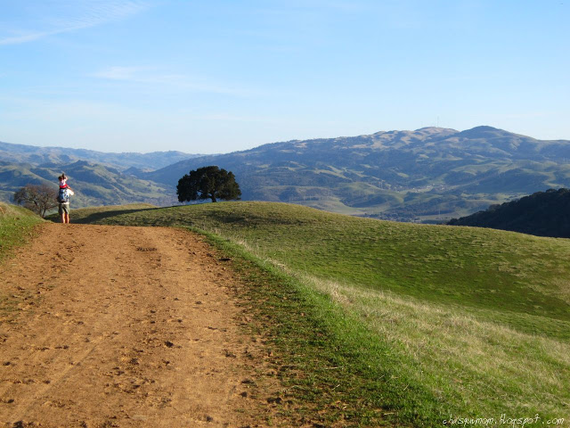
This is not about bagging a 14er, not even close! Tolman Peak does not reach 1,000 ft but that does not mean we didn't get great views of the San Francisco Bay Area!

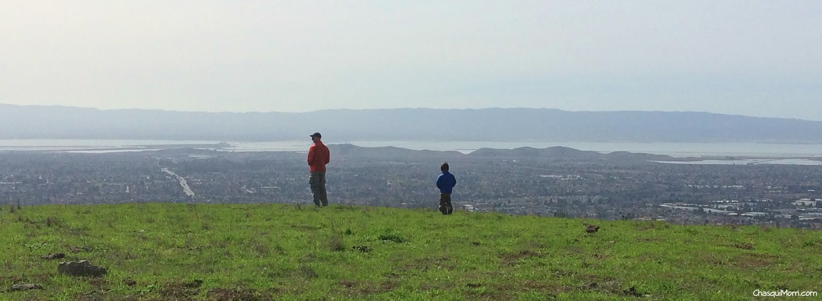
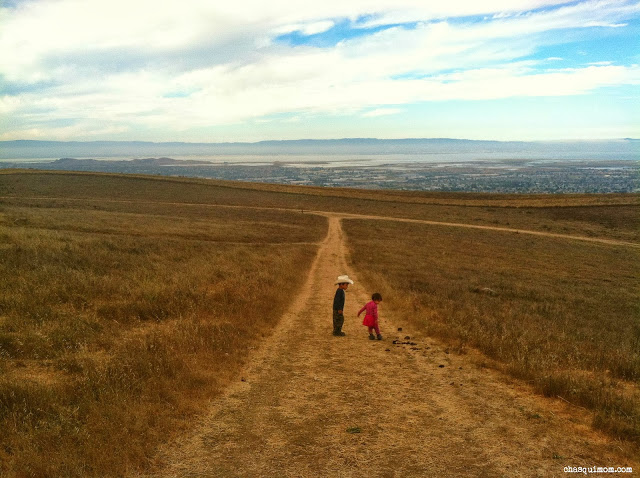
View of the San Francisco Bay Area from Tolman Peak

If you are not familiar with "Peak Bagging", that is an outdoor term for reaching the peak of a mountain like one of Colorado's famous mountains above 14,000 feet.  Technically our little family "bagged" Tolman Peak, at only 947 ft, it is still peak bagging!  Tolman Peak is more like a hill but from the top you can see the entire San Francisco Bay Area, from the South Bay to out past San Francisco.

Garin Dry Creek is surprisingly remote once a mile has gone by.  I would consider Garin Dry Creek an "urban outdoors" park because its right up against two cities Union City and Hayward.  Surrounded by California State East Bay, cemeteries and residential areas.  Yet on almost every occasion we've been there we have encountered wildlife (alive and dead) and felt like we were miles away.

"Tolman Peak has a little kick to it!"

On this warm winter day, we wanted a relaxing hike to let the kids burn some energy so we decided to hike at Garin Dry Creek, Tolman Peak.  We only need to hike to Gossip Rock and then we can say we have hiked on every trail at Garin Dry Creek!  It was a busy day at the park that even the May Road Entrance parking lot was full.  We actually had to park outside on the Mission Blvd, which added 0.55 miles to this 4.75 mile hike (from May Parking Lot).
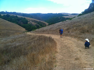
Shady May Trail

May Trail is very shady and is not much like the rest of the park, which is exposed grassy hills.  Our kids have issues with hiking fast up even the slightest uphill so even though Tolman Peak has some elevation gain the majority of the hike is perfect for my not-so-energetic two year old daughter.  We continued onto High Ridge Loop Trail which is a fire road and could still hear all the traffic sounds from cars and the BART train.

Ladybugs were plentiful throughout the day which motivated the kids moving to find the next ladybug down the trail. Near the fork of High Ridge Loop and Tolman Peak Trail there was a waterhole for the grazing cattle and they all were laying in the shade. When I'm hiking alone with the kids, we normally hike to the waterhole and the kids throw rocks in the pond so the kids were a little astonished to see the cows in "their spot".

Our kids were in their

hiking "groove"

 along the Tolman Peak Trail which followed a creek that actually had water flowing in it!  Dry Creek was not dry and the sounds of croaking frogs made my kids happy.  We reached a little bridge that was surrounded by large Pine and Eucalyptus trees, all of a sudden I realized that even though we were probably less than 2 miles away from the busy streets of Hayward I felt I like I was 100 miles away from civilization.  No more traffic or train sounds, all the other park visitors were gone and we were alone with the sounds of the croaking frogs and my kids screaming! Sometimes there's no need to drive far away to get into the Great Outdoors.

After a little break near the bridge, we finally made it to the base of Tolman Peak and it was time to hike uphill.  We didn't want the kids to get burned out nor spend hours on end going up hill so I carried my daughter in my Ergo and my husband picked up our boy unto his shoulders.  Tolman Peak definitely has a little kick to it, let's just say my husband and I got a workout!

I love My Hiking Family!

Where is Tolman Peak?

Obviously Tolman Peak exists...I was just a little confused about where the actual peak was. According to the

East Bay Regional Park District

map, Tolman Peak was just south of the South Fork Trail near the bench, but I could not find the circular peak marker that you normally find at the peaks.  According to our Garmin GPS the peak was north of the bench near some rock formations, either way we were at the top and we enjoyed our views of the Bay.

Even if it's a warm day down below in suburbia-land, going up on the East Bay Hills always allows for the direct chilly ocean wind cut right through us.  I always think that we won't need our jackets but a few minutes on top of Tolman Peak led to wearing every piece of clothing in our packs!  After we all bundled up we all hiked down on South Fork Trail, which was a single track trail and somewhat steep in sections.

We tried to hurry back to the car since I was cold and couldn't warm up! My daughter decided that she wanted to hike at her own pace so it took a little longer than we hoped but I'm always happy when she hikes because she doesn't hike long distances like her brother. We were hungry and only packed snacks since we planned on eating out afterwards, but we were all running low on energy and needed to finish.  Promises of treats, finding more ladybugs moved everyone along and we finally finished our lovely family peak bagging at Tolman Peak.

Side Note:  

The great thing about hiking with kids is that everything slows down and you get to enjoy the small beauties of nature.  The San Francisco Bay Area never gets real "Winter" weather other than rain and with due to drought conditions in California our East Bay hills have been terribly dry.  Even with the tiny bit of rain we have received recently the hills been showing signs of Spring.

Trip Report

: Garin Dry Creek Regional Park 

Who: Family - Two Adults and two toddlers

Mileage: 5.3 miles (From the Mission Blvd)

Time: 4 hours - Toddlers partially carried

Elevation Change: Approx 1,000 ft 

Family Friendly: Moderate

Trail Directions (Lollipop)

: From May Rd Entrance Parking Lot - May Trail 0.12 Miles - Slight right onto High Ridge Loop 0.32 miles - At the 2nd fork continue straight to Tolman Peak Trail 0.88 miles - At the Fork take a left (counter clockwise) continue on Tolman Peak Trail for another 0.82 miles - Right onto South Fork Trail for 1.29 miles and continue back Tolman Peak, High Ridge Loop and May Trail to parking lot.

I love my urban outdoor parks! What's your go to park whether urban or not?

Related Posts and Links:

  1. Implosion Hike...What's Not to Like?!
  2. A Chilly Hike at Garin Regional Park
  3. New Year's Day Hike: Garin Dry Creek
  4. Garin/Dry Creek Regional Park

Join in on the conversation by leaving a comment here! You can also join in on the conversations on 

Chasqui Mom's Facebook

Instagram

 and 

Twitter

 that is updated daily with outdoor activities and other wonderful posts and links from #OutdoorFamilies!

Family Hiking Adventure Completed: 2013 Trails Challenge

In the beginning of 2013, I signed up for the Trails Challenge through Regional Parks FoundationEast Bay Regional Park District, (EBRPD) and Kaiser Permanente.  Its a program to promote "Healthy Parks, Healthy People" for Bay Area Residents to explore the parks as well as promoting healthy living!  Each year the program comes out with a list of specific trails in parks that must be completed: Five of the listed trails or 26.2 miles (marathon) of trails.  We completed the challenge by hiking but the challenge can also be completed by biking the trails.

Last year I was unable to complete the challenge due to travel and illness but this year not only did I complete the five trails but we did it as a family, hiked over 26.2 miles in East Bay Parks!  We also had a lot of fun exploring my local East Bay parks.  Here's a little overview of all the parks we visited this year!


Mileage: 2.5 Miles
Memorable Fact: This was my FIRST time hiking solo with my two toddlers.


Mileage: 5.2 miles
Memorable Fact: Never seen the hills so green.


Mileage: 3.4 miles
Memorable Fact: We hiked very close to cows!


Mileage: 7.1 miles
Memorable Fact: Accidentally hiked in the dark, heard coyotes and it's the HARDEST hike I've done in the East Bay hills.


Mileage: 3.1 miles
Memorable Fact: The Four "Famous" Trails Intersection are on this hike.


Miles: 2.6 miles
Memorable Fact: The longest 2.6 miles we hiked with our toddlers, great views of the SF Bay.


Miles: 2.5 Miles
Memorable Fact: First time hiking along the quarry.

The Trails Challenge is a great way to explore East Bay parks, stay healthy, a great way to get motivated to get outdoors.  Living in the San Francisco Bay Area is a very urban environment but we definitely get outdoors in our surroundings.  National and State Parks are great but local parks are my go to places almost on a daily basis.  Can't wait for 2014 Trails Challenge!


Do you have a favorite local East Bay Regional Park? For those not in the East Bay, what is your favorite local park?

Join in on the conversation by leaving a comment here! You can also join in on the conversations on Chasqui Mom's Facebook and Twitter that is updated daily with outdoor activities and other wonderful posts and links from #OutdoorFamilies!

Family Fun at Keller Beach - Point Richmond

Keller Beach is a small beach within the boundaries of Miller Knox Regional Shoreline in Point Richmond.  Over the summer, we headed over to Keller Beach so our kids could splash around in the Bay, after we finished hiking in the hills of Miller Knox as part of one of our 2013 Trails Challenge hikes.

I wasn't expecting TOO much from a a San Francisco Bay beach but I was pleasantly surprised with Keller Beach.  It was a small beach which reminded me a "White Sands" beach that we visited on the Big Island, Hawaii so immediately it brought back memories of our family trip to Hawaii.

I read some reviews on Keller Beach prior to going and visited the East Bay Regional Park District (EBRPD) website to read about swimming in this section of the San Francisco Bay.  Certain sections of the SF Bay are not safe to swim in because of the high levels of bacteria.  Keller Beach is close to the ocean inlet so its more "ocean" water than "bay" water like in the south bay but the EBRPD regularly tests water at Keller Beach.

During our visit the water was safe to swim and when we arrived  people were splashing and swimming in the calm cold bay.  Our children are not really "water babies" but the love the idea of  "swimming" near the water.  They just really like to play in the mud, wet sand, sand dunes etc.  So they spent the rest of the afternoon running away from the waves, getting their feet wet and through mud into the air!

We arrived on a gorgeous, perfect Bay Area weather day....not too hot, not too cold but I can imagine how chilly it would get there when the infamous San Francisco Bay fog rolls in.  The beach must get also very stormy when we get a bad weather storm comes in.

Mount Tamalpais and the San Rafael Bridge

Keller Beach has restrooms, showers and picnic tables, no-fee beach and has FANTASTIC views of Mount Tamalpais, San Rafael Bridge and the rest of the Bay.  Some reviews I read had complaints of "too much" seaweed and how the neighboring residents should clean up the seaweed....apparently these people have never gone to a beach.

Keller Beach is a great place to dip you toes or swim (if you want) on the Bay, especially after a hiking at Miller Knox Regional Park.  Once again an urban EBRPD park has changed my point of view of the urban outdoors.

Do you know of any urban outdoor areas that have surprised you?

Join in on the conversation by leaving a comment here! You can also join in on the conversations on Chasqui Mom's Facebook  and Twitter that is updated daily with outdoor activities and other wonderful posts and links from #OutdoorFamilies!

Related Posts and Links:

  1. Family Urban Hiking at Miller Knox Regional Shoreline
  2. Keller Beach | Miller Knox Regional Shoreline - East Bay Regional Park District

Hiking Along Quarry Lakes Regional Recreation Area

Quarry Lakes Regional Recreation Area

is a local East Bay Park located in Fremont, California.  In all my years of living near by we have never visited this park!  I've seen it hundreds of times, driving by it and seeing it from above on BART (the train) but once again the

2013 Trails Challenge

brought us to a nice little park.  If you would like to read about our other 2013 Trails Challenge hikes

please click here

!

Quarry Lakes is a very family friend recreation area, activities including hiking, biking, swimming, fishing, picnicking, boating, dog walking as well as hosting many organized walks and running events!  Quarry Lakes is located near the Niles District near the border of Fremont and Union City surrounded by a residential area, there is a $5 parking fee.

Our 2.5 mile hike started on Old Creek Trail (about 1 mile) near the Boat Launch parking lot, the trail is just a gravel path wide enough for bikes, walkers and hikers.  There are lots of benches around the lakes to take breaks!  As parents we've recently decided that our son will no longer be carry on our hikes since he's weighing 40 lbs or more and our backs can't take it anymore, so our hikes have significantly been shorten and have very little elevation.  Long story short Quarry Lakes is a great place to for my son to hike!

Along Old Creek Trail we saw Canadian Geese!

We skipped rocks!

And most importantly played in the dirt! My Dirt Angel Girl!

We made it to the Western Pacific Trail which follows the BART Tracks....my son got excited and screamed with glee every time a train passed by!  We saw a little lizards and lots of vultures flying above.  It was a great easy hike to stretch our legs, complete another 2013 Trails Challenge hike and get outdoors!!

Implosion Hike...What's Not to Like?!

Saturday, August 17, 2013 was the last day Warren Hall stood at

California State University East Bay

(CSUEB) in the Hayward Hills.  As a 2004 CSUEB graduate (formerly known as Cal State Hayward), I wanted to see where I had many computer, accounting, french classes and the building where I paid thousands of dollars go down into the ground.

Photo Courtesy of 

+Paul McWilliams

 of 

Not a Moment to Lose

We decided to hike out to the hills south of Warren Hall at Garin Dry Creek Regional Park, a short 1.5 mile hike to where we wanted to set up.  The implosion was schedule for 9:00 a.m. so we woke up early, got the kids ready and headed out to Garin Dry Creek at 20 minute drive.  Garin Dry Creek is a very family friendly park for hikers, so far in the past year we have visited this park five times with our toddlers!

Our toddlers were terribly cranky that morning and everything was a struggle...getting out the door to hiking this very easy hike.  My three year old son has done more difficult hikes than this 1.5 mile hike but he was just not a happy hiker that morning.  My daughter also wanted in and out privileges from her carrier and she was not happy that we did not grant her those privileges.  I was a little worried that we were going to miss the implosion because we only had one hour to make this 1.5 mile hike.  I know that sounds ridiculously slow but if you have ever hiked with toddlers one mile an hour is usually a normal pace.

All the hikers, mountain bikers and photographers that we encountered on the trail had the same idea to go up on the hills behind Warren Hall so there was a steady flow of people around us.  We started our hike on Old Homestead Trail (0.25 miles) to Peak Loop Trail (0.8 mile).  As we arrived to the intersection of Peak Loop and Vista Peak, we saw all the spectators on the hills ready with their camera and I saw top floors of Warren Hall.  As we turned up a slight hill we heard the implosions go off and down came Warren Hall...I was a little irritated that we weren't situated to take pictures but I did see the building go down with my own eyes.

Thankfully, I had a Google+ friend 

+Paul McWilliams

 who was stationed down at a parking lot on Mission Blvd and he was able to take the moving picture above.  My kids were a little scared when they heard the implosion but they soon calmed down and made it up the hill so we could see the smoke disappear.  We talked to other bystanders, saw a rancher and his daughter ride by us on a horse and once everyone had left we decided to get closer to see the wreckage.

We continued back on Peak Loop Trail for another 0.44 miles when we realized that the hill in the distance were we saw a lot of spectators was actually not in Garin Dry Creek but on CSUEB property.  It seemed like it was an impromptu trail and we thought about crossing the little valley to get to it but decided against it.  We weren't planning on doing an actual hike but we ended up hiking in a new section of Garin Dry Creek that we've never been too, Ziele Creek Trail!

Beautifully Red Poison Oak ~ Ziele Creek Trail

I don't know how many times I can say this, but Garin Dry Creek is a very family/toddler friendly park difficulty wise, except for all the poison oak around the shaded Ziele Creek area.  If your child understands what poison oak is then great, but my son does not under completely understand what it is.  He's starting to understand not to touch it because it can hurt him.  He actually grabbed a whole branch but didn't get a rash. On the other hand, my husband who barely brushed some poison oak had to deal with rashes for almost two weeks.

We actually got a little turned around as well as some other hikers across the creek due to the fallen leaves on the trail which made it disappear...technically we weren't lost but I can see how easily you can lose the trail.  I guided the hikers across the creek to the trail and then we found the actual trail which was a little bit above us on the hill.  Back on the trail we continued trucking along Ziele Creek Trail and eventually found a dead deer carcass in the semi dried up creek.

In our

first hike at Garin Dry Creek

, we saw a large buck in the distance and I've heard of mountain lion sightings at Garin Dry Creek, so I know there is lots of animal activity in this park surrounded by urbanization.  All along Ziele Creek we found animal bones (well I hope it was animal bones) so it was quite surprising to find a whole small deer carcass that looked almost like it recently was alive, that nature for you.

.

We eventually emerged from the shady Ziele Creek Trail (1.13 miles) and headed on a familiar trails, Peak Loop and Old Homestead Trail for another mile or so.  My son hiked the entire 4.4 mile trek and my daughter was carried so we actually hiked much faster than we normally do.  My son can hike about five miles when there's hardly any elevation change but my daughter is not so much a hiker yet.  She's a lover of dirt, the first step of becoming a hiker!

Trip Report: Garin Dry Creek Regional Park

Who: Family - Two Adults and two toddlers

Mileage: 4.4 miles

Elevation Change: 1,031 ft

Family Friendly: Moderate

An implosion hike was a great way to see Warren Hall go down and spend our Saturday morning with our kids.  Just for fun here's a

close up NBC's video

of Warren Hall's last stand!  Thanks for the memories Warren Hall and for giving us one more family memory to add to our list!

var nbcLP={};nbcLP.aRandomNumber=Math.floor(Math.random()*10000);nbcLP.currentPageLoc=encodeURIComponent(window.location.href);nbcLP.currentSiteLoc=encodeURIComponent(window.location.host);nbcLP.defaultWidth=652;nbcLP.defaultHeight=367;nbcLP.cmsID="220054851";nbcLP.vidPid="QUnvqkmrbIfQ";nbcLP.vidSec="TK";nbcLP.vidSubSec="TK";nbcLP.vidFrame=document.getElementById("nbcLP220054851");nbcLP.vidFrame.style.border="none";nbcLP.vidFrame.width=nbcLP.defaultWidth;nbcLP.vidFrame.height=nbcLP.defaultHeight;nbcLP.vidFrame.scrolling="no";nbcLP.vidFrame.src="http://www.nbcbayarea.com/templates/nbc_partner_player?cmsID="+nbcLP.cmsID+"&videoID="+nbcLP.vidPid+"&width="+nbcLP.defaultWidth+"&height="+nbcLP.defaultHeight+"&sec="+nbcLP.vidSec+"&subsec="+nbcLP.vidSubSec+"&turl="+nbcLP.currentSiteLoc+"&ourl="+nbcLP.currentPageLoc+"&rand="+nbcLP.aRandomNumber;

Related Posts and Links:

  1. Not a Moment to Lose - Paul McWilliams
  2. Garin Dry Creek Regional Park
  3. A Chilly Hike at Garin Regional Park
  4. New Year's Day Hike: Garin Dry Creek
  5. WATCH: Cal State East Bay's Warren Hall Imploded
  6. California State University East Bay, Hayward
  7. East Bay Regional Park District - Garin Dry Creek Pioneer Regional Park