2013 Trails Challenge

Family Hiking Adventure Completed: 2013 Trails Challenge

In the beginning of 2013, I signed up for the Trails Challenge through Regional Parks FoundationEast Bay Regional Park District, (EBRPD) and Kaiser Permanente.  Its a program to promote "Healthy Parks, Healthy People" for Bay Area Residents to explore the parks as well as promoting healthy living!  Each year the program comes out with a list of specific trails in parks that must be completed: Five of the listed trails or 26.2 miles (marathon) of trails.  We completed the challenge by hiking but the challenge can also be completed by biking the trails.

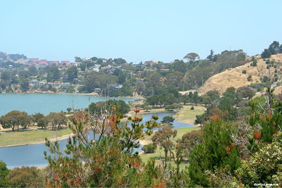
Last year I was unable to complete the challenge due to travel and illness but this year not only did I complete the five trails but we did it as a family, hiked over 26.2 miles in East Bay Parks!  We also had a lot of fun exploring my local East Bay parks.  Here's a little overview of all the parks we visited this year!


Mileage: 2.5 Miles
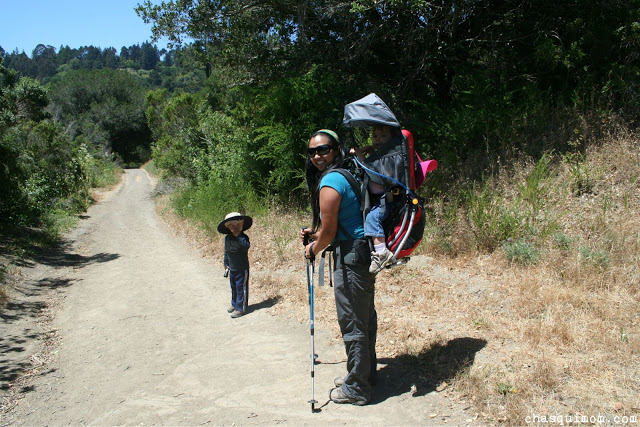
Memorable Fact: This was my FIRST time hiking solo with my two toddlers.


Mileage: 5.2 miles
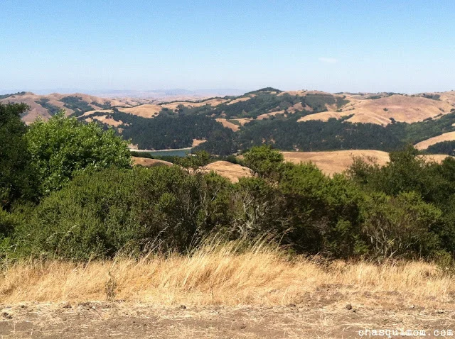
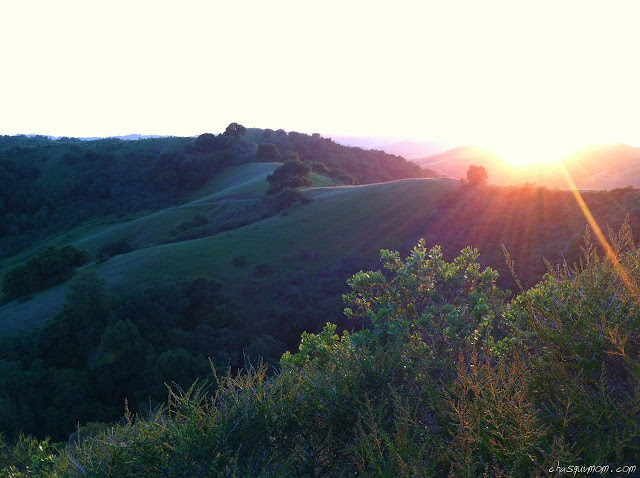
Memorable Fact: Never seen the hills so green.


Mileage: 3.4 miles
Memorable Fact: We hiked very close to cows!


Mileage: 7.1 miles
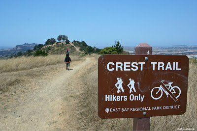
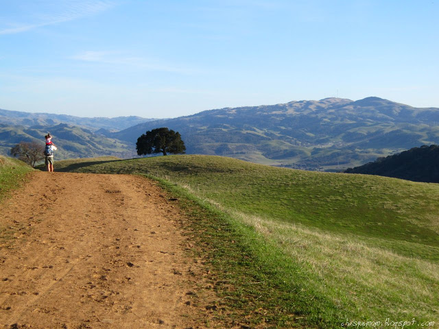
Memorable Fact: Accidentally hiked in the dark, heard coyotes and it's the HARDEST hike I've done in the East Bay hills.


Mileage: 3.1 miles
Memorable Fact: The Four "Famous" Trails Intersection are on this hike.


Miles: 2.6 miles
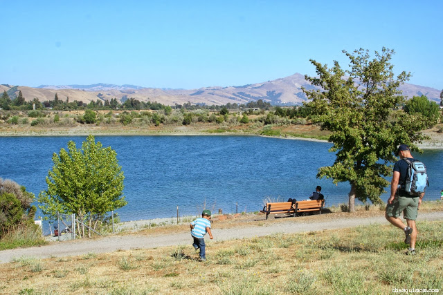
Memorable Fact: The longest 2.6 miles we hiked with our toddlers, great views of the SF Bay.


Miles: 2.5 Miles
Memorable Fact: First time hiking along the quarry.

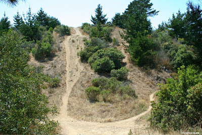
The Trails Challenge is a great way to explore East Bay parks, stay healthy, a great way to get motivated to get outdoors.  Living in the San Francisco Bay Area is a very urban environment but we definitely get outdoors in our surroundings.  National and State Parks are great but local parks are my go to places almost on a daily basis.  Can't wait for 2014 Trails Challenge!


Do you have a favorite local East Bay Regional Park? For those not in the East Bay, what is your favorite local park?

Join in on the conversation by leaving a comment here! You can also join in on the conversations on Chasqui Mom's Facebook and Twitter that is updated daily with outdoor activities and other wonderful posts and links from #OutdoorFamilies!

Hiking Along Quarry Lakes Regional Recreation Area

Quarry Lakes Regional Recreation Area

is a local East Bay Park located in Fremont, California.  In all my years of living near by we have never visited this park!  I've seen it hundreds of times, driving by it and seeing it from above on BART (the train) but once again the

2013 Trails Challenge

brought us to a nice little park.  If you would like to read about our other 2013 Trails Challenge hikes

please click here

!

Quarry Lakes is a very family friend recreation area, activities including hiking, biking, swimming, fishing, picnicking, boating, dog walking as well as hosting many organized walks and running events!  Quarry Lakes is located near the Niles District near the border of Fremont and Union City surrounded by a residential area, there is a $5 parking fee.

Our 2.5 mile hike started on Old Creek Trail (about 1 mile) near the Boat Launch parking lot, the trail is just a gravel path wide enough for bikes, walkers and hikers.  There are lots of benches around the lakes to take breaks!  As parents we've recently decided that our son will no longer be carry on our hikes since he's weighing 40 lbs or more and our backs can't take it anymore, so our hikes have significantly been shorten and have very little elevation.  Long story short Quarry Lakes is a great place to for my son to hike!

Along Old Creek Trail we saw Canadian Geese!

We skipped rocks!

And most importantly played in the dirt! My Dirt Angel Girl!

We made it to the Western Pacific Trail which follows the BART Tracks....my son got excited and screamed with glee every time a train passed by!  We saw a little lizards and lots of vultures flying above.  It was a great easy hike to stretch our legs, complete another 2013 Trails Challenge hike and get outdoors!!

Family Urban Hiking at Miller Knox Regional Shoreline

I love exploring the not-known and underdog parks of the Bay Area.  A couple weeks after we had recovered from our last backpacking trip in early Julywe decided to go on an local hike.  I had already completed the five required trails the East Bay Regional Park District (EBRPD) lists in the 2013 Trails Challenge but my husband needed one more to complete the challenge, so we headed out to Miller Knox Regional Shoreline in Richmond.

Old Country Road to West Ridge Trail

When I think of Richmond lots of negativity pops up in my mind, gangs, shootings, high murder rates so when the EBRPD listed this hike of course I was very interested because I didn't even know there was a shoreline park in Richmond and second of all after reviewing Miller/Knox's website I saw that it had a beach! Just because a place has a bad reputation don't be scared to go exploring and in this case urban hiking!

Urban hiking might mean different things to people but to me it means exploring parks in the immediate urban area, such as the San Francisco Bay Area as well as "hiking" in large cities like San Francisco!  You can definitely get some good hikes and elevation change with the hills in San Francisco!!

Driving to Miller/Knox was a little different because as soon as we got off the freeway it was very industrial, followed by million dollar homes, boats on the Marina and then a pond/playground park at Miller/Knox.

The hike began at Old Country Road Trail with an immediate somewhat steep climb (20%).  We had decided after our last backpacking trip that my son's time of being carried in a carrier had ended, so we were going to choose easier hikes, but somehow we keep ending up picking "steep" hikes. Oh well, my little three year old boy is a crazy good hiker for his age.  This section was very tiny and my daughter was also very determined to hike so we let her slowly climb the "mountain".

The views going up Old Country Road were fantastic.  It was still a little foggy around the coast but we could see the tops of Golden Gate Bridge, city views of San Francisco, Angel Island, Mount Tamalpais, San Rafael Bridge and the actual Bay was looking great that day.  Hiking by the Bay is a little tricky because the weather is so finicky, when the wind is blocked it gets rather warm, then it's very cold and breezy, then the fog could roll back in at any moment.  So even if it's a sunny day I always dress in layers, bring sweaters and jackets when hiking along the Bay.

The Pond at Miller Knox

The Pond at Miller Knox

Mount Tamalpais

Mount Tamalpais

Can you see the tops of Golden Gate Bridge?

Can you see the tops of Golden Gate Bridge?

We made it to the top of the first hill and took a little break and enjoyed views of the marina below us.  My son climbed the only tree at the top of the hill while my daughter played in the dirt and my husband decided to Zillow the houses in the marina, quite expensive I might say.  There were apartments, townhouses and single family homes in this tiny marina.

Taking in the view of the Marina

We had seen the hill we were going to come down when we first started the hike and I had wished we had brought our hiking poles but we hadn't.  At the steepest point it was a 42% grade (down hill) hike and our kids were determined to hike it themselves, so while my husband and son made it down pretty quick I spent my time trying to help my daughter to not slide down hill.  I am notorious with falling down on the trail, even when I'm just standing still, I know it's ridiculous.

West Ridge Trail (left) Old Country Road (right)

West Ridge Trail (left) Old Country Road (right)

At this point, I know why the EBRPD categorized this hike as moderate due to all of its hills.  I read a little later that this used to the a Richmond Rambler Motorcycles trails, which makes sense with all the hills.  Now it's open to hikers (w/dogs), equestrian riders and mountain bicycles on specific trails.  We huffed it up to the second hill, called False Gun with even more great views of the Bay but didn't stay too long because the wind was almost knocking us over!

I love dirt!

Heading up to False Gun

Heading up to False Gun

We left False Gun and headed on to a "hiker only" trail called Crest Trail. We had a little confusion there because there was fence blocking an obvious trail that had the "Restoring Land" sign and hikers hiking on the forbidden land.  We didn't go over the fence...headed on the correct trail that had a switch back that took us back to where we thought we were going to in the first place the radio towers.

Crest Trail to Radio Towers

Crest Trail to Radio Towers

It's a Spaceship!!

It's a Spaceship!!

It was much less windy once we came off the ridge so we were able to warm up, but once we started up to the radio towers again the wind picked up with a furry!  My son is a great hiker but if temperature is a little to warm or he's a little out of sorts then he will drag his feet.. The second he saw the radio towers, he yelled "Mommy let's go see the spaceship!!".  Sure enough that helped him get to the top.

It was almost all down hill after the radio towers so my son got into his hiking groove and my daughter fell asleep in my ERGO carrier.  With all that cool wind blowing in her face she had no other choice than to fall asleep! It was a really gentle down slope on Marina View Trail, behind a large water tower all the way down to the old Richmond Ramblers Motorcycle building off of Dornan Grove Trail.  Dornan Grove Trail ends on Dornan Dr (paved street).  We continued hiking on the street for a few minutes before getting back on Old Country Road (trail) again.

Chasqui Mom

Chasqui Mom

Richmond Ramblers Motorcycler

Richmond Ramblers Motorcycler

There were small sections through the hike where we found blackberries, but once we got back onto Old Country Road, we were surrounded by a forest of blackberry bushes!

Didn't you know Batman also hikes?!

Didn't you know Batman also hikes?!

Blackberry Forest!!!

Blackberry Forest!!!

It was a quick easy up hill again towards the Old Country Road spur we started on and soon we were off to explore Keller Beach, which will be coming soon!

I'm sure glad that we decided to do a family hike in this urban park.  Miller/Knox is just another reminder that you really don't have to drive far our of the urban environment to enjoy the outdoors.  Have you found treasure parks like Miller Knox Regional Park in your urban world?  What did you like the most about your urban hike? Please leave your comments below!

Related Posts and Links:

Tilden Regional Park - 2013 Trails Challenge Completed!

This is my second year participating in the

Trails Challenge

 by the

East Bay Regional Parks District

.  Last year I did not complete the 

2012 Trails Challenge

 because of impeding travel and sickness, so this year I'm making sure not only to complete the minimum five trails required but I'm going for the Marathon Challenge, completing 26.2 miles of listed trails by the EBRPD, of course with my toddlers in tow.

Last week, I was able to enjoy a beautiful weekday hike with my children and my two friends, Lorena and Lucy at 

Tilden Regional Park

, Berkeley, CA.  If I hike during the week, I pick easy flat short trails because I'm usually alone with my children but since I was going to two other adults I thought this hike would be more adventurous.

This hike started at Inspiration Point, which looked over the golden East Bay hills.

Inspiration Point, Tilden Regional Park

I thought there would be a giant sign screaming "Inspiration Point", but there was a small information board which I couldn't read because my kids were trying to run into the parking lot so I asked a someone if we were at Inspiration Point and he said, "Of course! That's why you're inspired!" and smiled.  He probably saw my frantic attempts to stop my kids from running in to the parking lot...

We located the information kiosks and retrieved our park maps and headed to the trail-head which started on Nimitz Way.  Within two minutes of our hike, my son started crying for his flashlight which was in the car.  Thankfully, Lorena and Lucy watched the kids while I ran back to the car to get David's precious flashlight.  During my little jaunt back to the car I had my "revelation" of the 

Toddler Hiking Cycle

, check it out when you have a chance.

We really didn't hike on Nimitz Way, since it's a paved bike trail but we had to go through it to reach Curran Trail where our hike actually began.  It was a quick descent on Curran Trail for 0.13 miles before we took a quick right on Meadow Canyon Trail for 1.43 miles.  I didn't know that the intersection of the Four "Famous" Trails was actually at the Curran/Meadow Canyon Trail intersection, but we will get there soon enough.

Meadows Canyon Trail

Meadow Canyon Trail was mostly exposed slight downhill trail, with patches of shaded areas.  It was the perfect down hill trail that helped my toddlers hike most of the way.  I was considering bringing my double jogging stroller but I was not sure the trail would be wide enough or the terrain would be to rough for a stroller.  I brought my Deuter Kid Carrier 1 to carry my 21 month daughter and hoped my three year old son would hike most of the way.  I don't like hiking with our stroller but take it when I'm by myself with the kids.

Meadows Canyon Trail - My son is wearing my hat....

My son was still feeling a little run down from a cold and was complaining a little bit to be carried.  Lucy was kind enough to give my son a piggy back ride to the halfway point which was only 10 minutes away.  I know my son had it in him to keep walking but he was already on the "edge" after the earlier "almost" meltdown.  Once we reached the halfway point at the intersection of Meadows Canyon and Wildcat Gorge Trail a.k.a Lone Oak Picnic Area, we all had snacks and took a break.  There was a water fountain, toilet pit restrooms, picnic tables and benches at Lone Oak.

The kids ate Lorena's snacks!

There was even a water bowl for dogs at the water fountain, a very dog friendly park.  Throughout our entire hike, there were lots and lots of dogs.  Some were hiking their owners but the majority were dog packs with professional dog walkers.  My daughter was thrilled to see so many dogs at Tilden, this is a girl who played with street dogs in Mexico since she was nine months old, true story.  On the other hand, my son was NOT thrilled with the amount of dogs.  He's terrified of any dog that is not our two Shih Tzu's, even if they are tiny.  We had to pick my son up or block him from the dogs when we encountered them on the trail which also did not encourage him to hike.

My friends (who do not have children) got to experience a full on meltdown courtesy of my daughter when she did not want to leave the water fountain at Lone Oak.  My daughter threw her hissy fit and got over it within five minutes of being in the carrier.  While my daughter screamed, we started our hike on Wildcat Gorge Trail (0.78 miles) and we were quickly in a little field with hundreds of blue dragonflies.  I had never seen so many before in my life and my daughter had forgotten about the water fountain and enjoyed the dragonflies as well.

Dragonfly Field!

Wildcat Gorge Trail followed a creek that is designated a resource protection area for Rainbow Trout and California Newts, sadly we did not see any.  Wildcat Gorge was a very beautiful "green" trail which reminded me of our backpacking trip to

Point Reyes National Seashore

. The slight ascent up Wildcat Gorge was mostly shaded and easy enough for my daughter and son, it also had railings to protect the creek from dogs and people.  My daughter eventually was out of my carrier and tried to climb over the railing to the creek but of course I never let her succeed.

The creek!

Creek from Lake Anza

We took another break at the intersection of Wildcat Gorge and Curran Trail.  My kids happily threw rocks and of course my son was eventually splashing in the water getting all wet.  We only had 0.75 miles left to hike on Curran Trail, so I didn't mind if he got a little wet.  We debated whether going on to Lake Anza but I didn't know if I could handle another meltdown at Lake Anza knowing that my daughter would have a meltdown leaving the creek.  We opted not to go (next time...) and headed up Curran Trail.  My daughter had a longer hissy fit this time but eventually calmed down and fell asleep.

This section of Curran Trail was very shaded with Eucalyptus trees that made cracking sounds all the time, so I was a little paranoid about the branches breaking off since I've been warned by EBRPD rangers before.  My son was Lucy's hiking partner most of the trip and I with my daughter and Lorena.  We had good conversations and Lorena told me that Tilden's landscape reminded her of her country's landscape, El Salvador. It made me happy and sad that I could show her a little bit of her "home" country here in the Bay Area.

Somewhere on Curran Trail

The nice thing about hiking with friends vs. hiking alone, is that I get to show up in the pictures!  My son was struggling by this point and he needed his mommy, so we switched hiking partners and my little boy hiked with me.  I will take it until the day he doesn't want to hang out with mommy.  All throughout the day there was poison oak along the trail but this section of Curran Trail had an absurd amount of poison oak, so I held my son's hand so he wouldn't jump in it!

Tilden "El Salvador" Regional Park

We arrived at the Four "Famous" Trails intersection again and this time I knew we were there.  This is where the 

American Discovery Trail

Bay Area Ridge Trail

Mokelumne Coast to Crest Trail

 and the East Bay Skyline National Trail intersect.  I spent a few moments explaining to Lorena about the trails and we were both excited to take pictures at the trail marker.  I was so excited I slipped and fell down with my daughter in my carrier! My daughter did not even wake up with my tumble but I did give Lorena a scare!

Four "Famous" Trails

Before the fall!

Lucy did me the favor again and gave my son a piggy back ride for the last 10 minutes back to the parking lot.  We did a few more photo shots of the view at Inspiration Point before we headed home.  I think I need approximately two more short hikes or one longer hike to reach the Marathoner Challenge but Tilden Regional Park was my 5th park on the Trail Challenge list so my challenge is complete!

TRAIL REPORT

The trail loop is listed at 3.1 miles, but as always with extra running around with the kids we made it a 4.0 mile hike, in almost 4 hours or average 1.0 mph.

Elevation change of about 500 ft over 4 miles.

Inspiration Point - Nimitz- Curran - Meadows Canyon - Wildcat Gorge - Curran Trail

Related Posts:

Our system has encountered an error. This exception has been automatically logged and reported. F9C5YZMCM6XF7LS9HDNB

Adventures at Las Trampas Regional Wilderness

Last week we decided to do an afternoon hike at 

Las Trampas Regional Wilderness

, in San Ramon.  We started hiking later than we usually do about 4 p.m. but we thought we had a good 3 hours of sunlight left, so we started my fourth  

2013 Trails Challenge

 hike from the East Bay Regional Park District.

Note: All my pictures are from my iPhone, because my son decided to jump off the chairs at church with my camera in hand, land on it and break it...

We parked just outside the park's gate near Little Hills Picnic Ranch just in case if the parks gates were actually closed at 7 p.m. as the gate sign said.  After the eternity of packing everything and making sure everyone was dressed appropriately we started our 6.0 mile hike on Elderberry Trail and headed uphill towards the ridge.

Hiking up Elderberry Trail 

It was quite a warm day but there was perfect amount of sun, shade and wind that I never felt too hot.  Our three year old son, David has had a mental block about hiking since we last hiked at 

Pinnacles National Park

 and only wanted to be carried on daddy's ( 

+Jesse Avery

) shoulders.  My son can hike between 3-4 miles, that's how much energy my boy has and it's one of our main reasons why we continue hiking with our little ones.  So we decided to just encourage him to hike and after about 15 minutes of complaining he got over it and we had our little hiker back.

Elderberry Trail to Rocky Ridge Trail was 1.81 miles from outside the park parking lot, mostly up hill with some flat areas.  There were still an abundant of wildflowers in Las Trampas.  There were a lot of these purple flowered bushes as well as many California Poppies not to mentioned that the hills were still very green.

I also found 

Western Fence Lizard

 that allowed me to get a close up picture with my iPhone.  My daughter was fascinated with it.

Western Fence Lizard

We even encountered a flowing creek, where my children splashed in the water and threw little rocks in it.  One of the joys that my children have during hiking is finding a water source.  With a little bit of candy, chocolate and distraction David and Sophia hiked quite a bit up to Rocky Ridge View Trail.  An older hiking couple and I heard the woman say, "Now that's a hiker!".  I don't know if that was said about myself or my son but I thought it was a nice compliment.

The view from Rocky Ridge View Trail was amazing!

I could see as far past Mission Peak in Fremont, out past the Golden Gate Bridge as well as Mount Tamalpais and Mount Diablo.  I always feel like the Bay Area is really crowded with all its suburbs but there were miles and miles of empty rolling mountains that I could see from Rocky Ridge View Trail.  Another reason why I love the Bay Area, there is wilderness around us.  

We had a little break at the top and decided to carry the kids the rest of Rocky Ridge View Trail (0.38 miles) down Devil's Hole Trail because the couple who had just passed me told Jesse they had seen a few Rattlesnakes on the trail.  Sophia hadn't napped all day and David was already a little stressed because of group of young guys with a pack of four pit bulls all not on their leashes was near us. So I put Sophia in my Ergo carrier and David rode Jesse's shoulders. We eventually passed the pack of pit bulls and their owners and headed down Devil's Hole Trail for 1.3 miles.  This was a the beginning of Devil's Hole Trail, I wondered why it was called that...I was soon to find out.

Devils Hole started fairly easy until we started going downhill.  I think I left my hiking pole last month at Henry Coe State Park Visitor Center, so I didn't have any hiking poles for support.  Normally, I'm fine hiking without poles but I feel really off balance with my pack and my sleeping daughter in the front.  Secondly, I recently sprained my wrist when I took a tumble at Pinnacles National Park so I was nervous about falling down because it still hurts.  

+Jesse Avery

 and I hiked down very slowly on this very steep hill.

A flat part of Devil's Hole Trail, rare!

The were some large switchbacks for a while followed by a small portion of the trail that was flat (pictured above).  Along the way the normal grassy green hills turned into wooded areas, back to open areas which was nice because I love changing scenery.  The trail became very steep after the flat section so I stopped taking pictures to no fall over.  My toes were hurting from the steepness, weight of my pack and my toddler so I went extremely slow.  I hiked so slowly that I was about 20 minutes behind my husband.

We always wait for each other at a trail marker so I knew we would meet up again, but during those 20 minutes alone I figured about why Las Trampas is a wilderness! Turkeys gobbled all around me, deer tracks could be seen all over the trail, furry "poop" was all over the trails...evidence of coyotes.  I even heard coyotes nearby hiking down Devil's Hole Trail but didn't realize it until hours later.  I heard some hooting/howling and thought to myself that the pit bull pack and their owners where nearby but they never should up.  Also I had a sensation that some animal was nearby I just assumed it was the pit bulls, I guess it was my inner cave woman in me!

Jesse was waiting for me at the bottom of Devil's Hole Trail and my David was awake from taking a nap on Jesse's head/shoulders.  Poor Jesse, his shoulders hurt for the next couple of days! My legs were very shaky when I reached the bottom from coming down a steep hill.  I wasn't tired but my legs were so shaky, so I had some snacks, water and some Gatorade.  Devil's Hole was loud! More turkeys gobbled all around us, the babbling creek and there was even a crazy loud bird fight near by!

Sophia woke up but was still very sleepy and stayed in my carrier.  Coming down Devil's Hole, we saw the trail that we had to take back up that seem terribly steep, so they whole way down I was mentally preparing myself for the 1.26 mile of hike up on Sycamore Trail.  Jesse said, "You saw the trail?" I nodded and we just looked at each other like we have on many trails knowing that we were going to get our butts kicked.

Sycamore Trail started flat and then crossed a creek.  There was lots of poison oak around the trail so David was still being carried since he loves to touch everything.  We got to a portion of the trail that I wish I had a machete because the bushes were so overgrown.  Once again the landscape changed again and it almost looked "desert-ish", short bushes and lots of sage or what at least smelled like sage.  At some point we saw that we were not going on the trail we saw from Devil's Hole Trail but an even STEEPER one.  The one we saw looked flat compared to Sycamore Trail! The trail had pieces of wood nailed into the trail for steps....

My son was so energetic at this point that he was crawling up the rocky trail and yelled, "Look mommy, I'm hiking, I'm rock climbing!!" I'm glad he was so energetic because that allowed my husband to carry Sophia.  She wanted to hike but the trail was to steep for my 18 month old.  My son hiked/climbed the entire Sycamore trail, I was very impressed with my three year old hiking skills!

Sycamore Trail View

We only had about 45 minutes left of sunset and still had a couple of miles so we tried to hustle but as anyone know who has toddlers that's nearly impossible.  Sophia desperately wanted to walk and we were hiking at a snails pace.  I inadvertently scared her into being carried by Jesse because I yelled out to Jesse, "Do you hear the owl's?!" and she let out a scream and yelled "Big Owls!!" and cried for daddy, the protector.

My son was a little tired by now and we still had a multitude of switchbacks to hike, so we played a game to make Sophia feel safe and to keep David hiking.  David and I were lions and roared all along the trail to scare the owls away.  We finally reached the "top" and found some really cool rock formations which we couldn't enjoy because it was getting dark and Sophia was in need of a diaper change.  I noticed all this perfectly sculpted holes in the rocks and asked Jesse if he thought those were man-made.  Later I read that the wind created those holes and I never noticed it but apparently there was a wind cave on Devil's Hole Trail.  I was too paranoid about falling down Devil's Hole Trail that I didn't even notice the wind cave. Sadness.

It was actually very dark by now and getting very chilly and windy, so we bundled up the kids loaded them up and off we went to hike by moonlight.  Thankfully there was a half moon out so we had quite of bit of moonlight out.  I brought a flashlight but when we turned it on the batteries were dead of course! I don't know what time we made it to Rocky Ridge View Trail but all I remember was hearing a pack of coyotes howling nearby and realizing, "hmm there are animals out there...."  It was still almost 2 miles back to the parking lot but I could see the parking lot so that was very relieving.

My toes were killing me by this point and I really wish I had my hiking poles but thankfully my daughter had semi-fallen asleep so at least I didn't have a cranky baby.  We heard another pack of coyotes even closer this time, so my husband turned on music on his phone so my daughter could stay calm and to scare any coyotes away.  I was never really scared until we got wooded area and the moonlight could not shine through the branches.  I felt an animal presence to my right and heard it rustling in the bushes, whether it was a rabbit, deer or a coyote it really freaked me out so I got closer to my husband and held onto his arm.

After what seemed like an eternity we finally made it to the car and the kids wanted to eat McDonald's and we happily agreed.  Not our favorite food to eat after hiking but I just wanted to make my kids happy because they were scared.  

HIKING INFORMATION

The Trails Challenge listed this hike as 6.0 miles but for some reason we made it 1 mile longer!

Elderberry Trail - Rocky Ridge View Trail - Devil's Hole Trail - Sycamore Trail - Rock Ridge View Trail

Elevation Change.  That center part is Devil's Hole....

You can also see our hike on my Strava Link 

http://app.strava.com/activities/49644557

Lessons Learned:

  1. I need to get new hiking poles, ASAP!
  2. Read the description of trail (which I normally do) beforehand.
  3. This hike was probably not a toddler-friendly hike.
  4. To always follow my normal rules of bringing extra clothes and food, which I did.
  5. My daughter is scared of owls....

2013 Trails Challenge hike #4 is completed!

Our system has encountered an error. This exception has been automatically logged and reported. GWSK83D594H2PBECLGJ2